Population
According to the 2000 US Census, approximately 27,000 people reside
in the UIRW. This includes 12 incorporated cities and towns. The majority
or 54% of residents reside in these incorporated areas. The largest
incorporated city in the watershed, Decorah, has a population of 8,172.
The 2000 Census also reported that 6,807 families reside in the watershed.
Transportation
The UIRW is crossed by nearly 2000 miles of roads, hard surface or gravel.
Roads meander more than they do in other parts of the state, due to
the terrain, the high number of road miles creates a great number of
intersections with streams and rivers in the UIRW. GIS analysis revealed
1,233 road intersections with rivers and streams in the UIRW. The UIRW
contains no currently used railways. There is one airport located in
the UIRW; an airport with a 4,000 runway is located 2 miles southeast
of Decorah. The airport serves small jets and planes and is the only
known jet fuel provider in the UIRW. There are currently plans for expansion
of this airport. The Iowa DNR regulates 87 underground storage tanks
in the UIRW, 31 of these are currently active. The DNR also has recorded
38 leaking underground storage tanks in the watershed, 9 of which are
of high risk.
Climate
 The
annual mean temperature at Decorah, the approximate center of the watershed,
is 46.7° F. Decorah has recorded an all-time extreme high of 104°
F and extreme low of -43° F. Precipitation records reveal an average
of 33.4 inches of rain and an average of 39.8 inches of snowfall annually.
The average number of days with greater than 1.0” of precipitation
was 7.3, the average number of days with greater than 0.5” of
precipitation was 21.9, and the average number of days with greater
than 0.1” of precipitation was 65.6. The growing season (constant
temperatures above 32° F) averages 152 days. (Midwestern Regional
Climate Center)
The
annual mean temperature at Decorah, the approximate center of the watershed,
is 46.7° F. Decorah has recorded an all-time extreme high of 104°
F and extreme low of -43° F. Precipitation records reveal an average
of 33.4 inches of rain and an average of 39.8 inches of snowfall annually.
The average number of days with greater than 1.0” of precipitation
was 7.3, the average number of days with greater than 0.5” of
precipitation was 21.9, and the average number of days with greater
than 0.1” of precipitation was 65.6. The growing season (constant
temperatures above 32° F) averages 152 days. (Midwestern Regional
Climate Center)
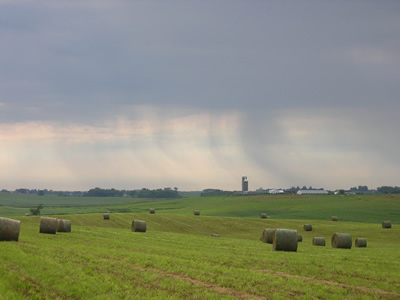
Agriculture/Farming
Analysis conducted by the UIRW Project identified 1,606 possible livestock
producers in the watershed, as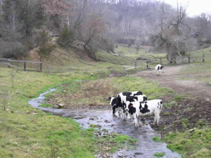 of publication; 28% have been ground truthed and confirmed. The 2002
NASS survey and GIS analysis also estimated that farms in the UIRW house
approximately 97,000 cattle, 180,000 hogs and 3,100 sheep. The majority
of livestock producers in the UIRW have head numbers below 300 animal
units and therefore do not meet the definition or requirements of a
Confined Animal Feeding Operation (CAFO).
of publication; 28% have been ground truthed and confirmed. The 2002
NASS survey and GIS analysis also estimated that farms in the UIRW house
approximately 97,000 cattle, 180,000 hogs and 3,100 sheep. The majority
of livestock producers in the UIRW have head numbers below 300 animal
units and therefore do not meet the definition or requirements of a
Confined Animal Feeding Operation (CAFO).
The average value
of an acre of land in the UIRW was estimated to be $2,629, which is
in line with the State of Iowa average (2004 Iowa Land Value Survey).
According to ISU Extension, farmers in the UIRW average a net cash return
that is $13,000 les that the State of Iowa Average.
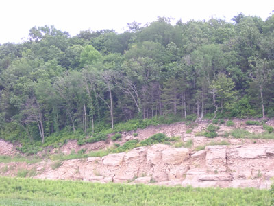
Geology/Karst
The Upper Iowa River flows through an area of topography and vegetation
unlike any other region of Iowa. Much of the watershed is in the “Driftless
Area” or Paleozoic Plateau landform. This area was bypassed by
the last continental glacier. The area is characterized by differential
weathering and erosion that results in a steep, rugged landscape referred
to as “karst” topography. Karst topography is defined by
land that is underlain by soluble bedrock, such as limestone, and characterized
by depressions in the ground, or sinkholes, caves, and underground drainage.
Because water can enter the subsurface easily through conduits and fractures
in the soluble limestone bedrock, karst aquifers are highly susceptible
to contamination. Karst topography features in the watershed include;
springs, streams that disappear into bedrock fissures, sinkholes, caves,
and steep, highly erodible hillsides. These features facilitate direct
mixing of surface and ground water. Karst experts typically measure
the development of karst by the number of sinkholes, springs and known
caves. The UIRW has thousands of sinkholes, hundreds of springs and
dozens of known caves.
 The
Paleozoic Plateau portion of the watershed also has shallow, near-surface
bedrock with karst development in Paleozoic carbonate strata (Prior,
1991). The water quality impacts of non-point source contamination of
shallow groundwaters in the karsted Ordovician carbonates of the Galena
Group have long been the subject of continuing hydrogeologic investigations
by the Iowa Geological Survey (Hoyer et al., 1986; Hallberg et al.,
1989; Libra et al., 1991; Libra et al., 1992; Rowden et al., 1993; Rowden
et al., 1995; Liuet al., 1997; Liu et al., 2000) The University of Minnesota
and the Minnesota DNR consider surface and groundwater interchangeable
in Southeast Minnesota, including the Minnesota portion of the UIRW.
The
Paleozoic Plateau portion of the watershed also has shallow, near-surface
bedrock with karst development in Paleozoic carbonate strata (Prior,
1991). The water quality impacts of non-point source contamination of
shallow groundwaters in the karsted Ordovician carbonates of the Galena
Group have long been the subject of continuing hydrogeologic investigations
by the Iowa Geological Survey (Hoyer et al., 1986; Hallberg et al.,
1989; Libra et al., 1991; Libra et al., 1992; Rowden et al., 1993; Rowden
et al., 1995; Liuet al., 1997; Liu et al., 2000) The University of Minnesota
and the Minnesota DNR consider surface and groundwater interchangeable
in Southeast Minnesota, including the Minnesota portion of the UIRW.
The far western portion
of the watershed, in Howard and Mower Counties, lies on the edge of
a landform known as the Iowan Surface. This is a gently rolling to flat
landscape. This portion of the watershed also has different soils, vegetation
and topography. Historically the Iowan Surface, an area of high clay
content soils, was dominated by wetlands that filtered the surface runoff
before it drained to the karst areas further downstream in the watershed.
The wetlands on the Iowan Surface provided a natural filtration system
for the Upper Iowa River. After European settlement the wetlands were
tiled and converted to row crop production. The majority of the surface
water is now transported quickly off the Iowan Surface to the karst
areas of the watershed without the benefit of filtration. Several disappearing
streams are documented at the transition of the Paleozoic Plateau and
the Iowan Surface.
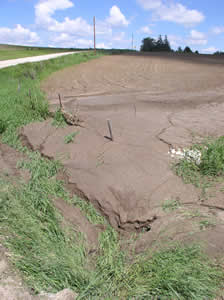
Sinkholes
A common karst feature of the watershed is sinkholes, which form when
the land surface collapses into subsurface voids formed in the slowly
dissolving rock. According to historic inventories conducted by the
Iowa Geologic Survey Bureau (IGSB) and the State of Minnesota there
are an estimated 2,596 sinkholes in the Upper Iowa River Watershed.
However, according to recent ground truthing conducted through NE Iowa
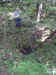 RC&D
in a twelve square mile study area of the UIRW, this estimate may be
low. The ground truthing documented 269 sinkholes in the same twelve
square mile area that the IGSB estimated to include 118 sinkholes. Most
of the sinkholes occur in rural areas where their main impact is rendering
land unsuitable for row-crop agriculture. Sinkholes have also resulted
in the failure of farm and other types of ponds, roads, and sewage-treatment
lagoons. Sinkholes act as a conduit for surface runoff to directly enter
bedrock aquifers. Both the Minnesota DNR and the Iowa Geologic Survey
Bureau recognize that sinkholes have implications for groundwater quality
in the Upper Iowa River Watershed.
RC&D
in a twelve square mile study area of the UIRW, this estimate may be
low. The ground truthing documented 269 sinkholes in the same twelve
square mile area that the IGSB estimated to include 118 sinkholes. Most
of the sinkholes occur in rural areas where their main impact is rendering
land unsuitable for row-crop agriculture. Sinkholes have also resulted
in the failure of farm and other types of ponds, roads, and sewage-treatment
lagoons. Sinkholes act as a conduit for surface runoff to directly enter
bedrock aquifers. Both the Minnesota DNR and the Iowa Geologic Survey
Bureau recognize that sinkholes have implications for groundwater quality
in the Upper Iowa River Watershed.
Sinkholes (and disappearing
streams) carry surface water to underground rivers and aquifers used
for drinking water. Water moving through underground rivers has been
documented by UIRW Alliance Partners using dye tracing in the UIRW.
These studies have demonstrated the ability to move very rapidly, sometimes
resurfacing many miles away in springs, waterfalls and wells within
hours.
Disappearing
Streams
 Disappearing
Streams, also referred to as losing streams, stream sinks or sieves,
are a feature found in the UIRW that has great implications for groundwater
quality. Disappearing streams are characterized by flowing water from
streams or rivers being transported underground via cracks or fissures
in bedrock at or near the streambed. Disappearing streams can act as
direct conduits for surface water contaminates to infiltrate groundwater
resources. Surveys conducted by UIRW Project personnel and the State
of Minnesota have identified 68 disappearing stream locations in the
UIRW, with a survey of additional disappearing stream locations ongoing.
Dye tracing studies in the Coldwater Cave area of the UIRW and near
the UIRW and Root River Watershed border have revealed groundwater basins
that defy traditional surface watersheds. The studies revealed surface
and groundwater systems that are not only interconnected but that fluctuate
depending on rainfall and flow volume. Some disappearing streams reemerge
further downstream in the same channel during low flow but contribute
to springs in other watersheds during high flow.
Disappearing
Streams, also referred to as losing streams, stream sinks or sieves,
are a feature found in the UIRW that has great implications for groundwater
quality. Disappearing streams are characterized by flowing water from
streams or rivers being transported underground via cracks or fissures
in bedrock at or near the streambed. Disappearing streams can act as
direct conduits for surface water contaminates to infiltrate groundwater
resources. Surveys conducted by UIRW Project personnel and the State
of Minnesota have identified 68 disappearing stream locations in the
UIRW, with a survey of additional disappearing stream locations ongoing.
Dye tracing studies in the Coldwater Cave area of the UIRW and near
the UIRW and Root River Watershed border have revealed groundwater basins
that defy traditional surface watersheds. The studies revealed surface
and groundwater systems that are not only interconnected but that fluctuate
depending on rainfall and flow volume. Some disappearing streams reemerge
further downstream in the same channel during low flow but contribute
to springs in other watersheds during high flow.
Decorah
Shale or Edge
An out-cropping of the Decorah Shale geologic unit further complicates
the geology of the UIRW. This geologic feature was named for the City
of Decorah and the shale outcropping that surrounds Decorah. Water flows
vertically through limestone bedrock until it hits the Decorah shale
layer. When water hits the shale layer it moves laterally until the
shale is exposed, typically on a side hill slope. At the point where
the shale layer out-crops, the water flows above ground through surface
vegetation until it bypasses the shale and re-enters the bedrock through
cracks or fissures. Many of the well known springs surrounding Decorah,
including Dunnings Spring, are the result of this formation. Many lesser
know small springs and side hill wetlands also surround the town. Water
from many of the lesser known features eventually flows underground
into deeper limestone layers to recharge deeper aquifers.
Vegetation on the Decorah Shale acts to filter contaminants in the water,
much like wetlands act to remove contaminates. This phenomenon was found
to be significant by the US Geologic Survey Bureau in the nearby City
of Rochester, Minnesota, which is also located in a valley surrounded
by outcroppings of the Decorah Shale. Building and infrastructure development
of the Decorah Shale portions of hillsides pushed the City of Rochester
to contract with the US Geologic Survey Bureau to conduct extensive
analysis of the hydrologic characteristics and filtering abilities of
vegetation along the Decorah Shale. The analysis found it would cost
the city millions of dollars in water filtration each year to replace
the action of the vegetation along the shale. The Decorah Shale has
been documented in the Minnesota portion of the UIRW and an effort to
locate and map the shale layer is underway in the Iowa portion of the
UIRW.
Coldwater
Cave
Iowa's longest and most spectacular cave is located beneath the surface
of the UIRW. By far the most significant cave of the Upper Midwest karst
region, Coldwater Cave was designated a National Natural Landmark by
the U.S. Department of the Interior in 1987. This status is accorded
to geologic and ecologic features considered to be of national significance.
(Coldwater Cave Project)
Since its discovery in the late 1960s, over 16 miles of passages have
been documented. The cave is situated in the Iowa part of the UIRW below
the topographic divide of the Coldwater and Pine subwatersheds of the UIRW. The cave consists of over four miles of borehole and stream
gallery, nearly a mile of parallel stream passage and another 11 miles
of infeeders and their associated offshoots. The cave system, which
is dendritic in its layout, is developed within a subtle carbonate ridge
bounded by surface drainages; some of the side passages cross under
these drainages. The entire area is mantled with loess and glacial till.
(Coldwater Cave Project)
of the UIRW. The cave consists of over four miles of borehole and stream
gallery, nearly a mile of parallel stream passage and another 11 miles
of infeeders and their associated offshoots. The cave system, which
is dendritic in its layout, is developed within a subtle carbonate ridge
bounded by surface drainages; some of the side passages cross under
these drainages. The entire area is mantled with loess and glacial till.
(Coldwater Cave Project)
There is only one natural entrance to the cave and it is a water-filled
spring that issues from the base of a 100 foot-tall bluff located within
the Cold Water Creek Conservation Area. Access to the historic entrance
requires SCUBA and the underwater entrance is currently gated. The system
also consists of two other springs and two paleo springs which are not
humanly enterable. Primary access to the cave is through a 94-foot shaft
that was drilled by the State of Iowa for researcher access in the early
1970’s. A second privately owned shaft entrance was drilled in
2003, and is located approximately 1 mile upstream from the primary
entrance.
Soils
Soils in the UIRW are dominated by Fayette (28.9% of the UIRW) and Downs
(16.6% of the UIRW) type soils. The remainder (54.5%) of the UIRW is
composed of 14 different soil types, but no type accounts for more than
10%.
 The
Fayette series consists of very deep well drained soils formed in loess.
Fayette type soils are found on convex crests, interfluves and side
slopes, uplands and treads and risers on high stream terraces. Slopes
range from 0 to 60 percent. Fayette soils are well drained and surface
runoff potential is negligible to high. Nearly level to gently sloping
areas of Fayette soils are cultivated, with the primary crops being
corn, soybeans, small grains, and legume hays. Steeper slopes of Fayette
soils are pastured, wooded or both wooded and pastured. The native vegetation
of Fayette soils is deciduous trees, mainly oak and hickory. (NRCS)
The
Fayette series consists of very deep well drained soils formed in loess.
Fayette type soils are found on convex crests, interfluves and side
slopes, uplands and treads and risers on high stream terraces. Slopes
range from 0 to 60 percent. Fayette soils are well drained and surface
runoff potential is negligible to high. Nearly level to gently sloping
areas of Fayette soils are cultivated, with the primary crops being
corn, soybeans, small grains, and legume hays. Steeper slopes of Fayette
soils are pastured, wooded or both wooded and pastured. The native vegetation
of Fayette soils is deciduous trees, mainly oak and hickory. (NRCS)
The Downs series
consists of very deep well drained soils formed in loess. These soils
are on interfluves and side slopes of uplands and on treads and risers
on stream terraces. Slopes range from 0 to 25 percent. Downs soil parent
material is loess. Downs soils are well drained and surface runoff potential
is negligible to high, depending on slope. Nearly level to gently sloping
areas of Downs soils are cultivated. The principal crops are corn, soybeans,
small grains, and legume hays. Steeper slopes are pastured, wooded or
both wooded and pastured. The native vegetation is big bluestem, little
bluestem, switchgrass, other grasses of the tall grass prairie and widely
spaced oak and hickory trees. (NRCS)
Hydrology
According to Stralhers Stream Order survey of Iowa there are 1,419 miles
of streams and rivers in the UIRW. The highest stream order in the UIRW
is a 5th order stream; a 7th order stream is the highest classification
and considered the most complex.
The UIRW has been
recognized by the State of Iowa as having some of the highest quality
and priority waters in the state. 109.4 miles of the Upper Iowa River
are designated as Class A, Human Contact. 152.2 miles of streams in
the UIRW have been designated as BCW, coldwater resource. The UIRW has
more miles of BCW streams than any other HUC 8 watershed in the State
of Iowa. The UIRW also contains 183.9 miles of HQR, high quality resource
waters, and 60.6 miles of HQ, high quality waters. In addition, there
are 159.2 miles of streams designated as BWW, significant resource for
warm water aquatic life, and 23.8 miles of stream designated as BLR,
limited resource for warm water aquatic life.
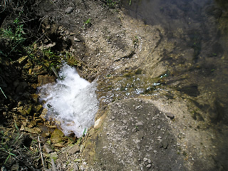
There are hundreds
of springs in the UIR watershed of which 186 are currently mapped, including
several well-known springs like Dunning’s Spring, Twin Springs,
and the second largest spring in Iowa, Siewers Spring. The largest spring
in Minnesota, Odessa Spring, flows into the UIR just before the river
enters Iowa. Odessa Spring has a discharge of 20,000 to 90,000 gallons
per minute. Water disappearing underground at York Blind Valley, ten
miles away in the Root River Watershed of Minnesota, resurges at Odessa
Spring, as shown by groundwater dye-traces conducted by the Minnesota
DNR. Water quality decline has been documented in many of the springs
in the UIRW. (Tjostem) Springs in karst watersheds are often fed by
sinkholes and losing streams, which are vulnerable to contaminates.
The area of land that contributes to any spring is known as its springshed.
Karst issues so greatly
complicate the hydrology within watersheds that there has been national
debate over the use of Hydrologic Unit Codes (HUC) that base watershed
boundaries almost entirely on topographic ridgelines without taking
actual hydrologic conditions into account. According to an Issues Paper
released on June 5, 2001, the US Geological Survey’s Hydrologic
Unit Boundaries (For 10- and 12-Digit HUCs) delineation of the HUC boundaries,
based almost entirely on topographic ridgelines not taking into account
actual hydrologic conditions, is a concern in karst regions and has
major implications for the following reasons:
• Safe Drinking Water Act reauthorization of 1996, Source Water
Assessment and Planning: The State of Iowa is required to delineate
water supply areas for drinking water systems and to inventory potential
contaminant sources. Using HUC boundaries in karst watersheds like the
Upper Iowa River watershed could incorrectly identify potential contaminant
sources in their supply area or, more significantly, discount sources
as being in one watershed, when in fact it contributes to another’s
drinking water supply.
• Total Maximum Daily Loads (TMDLs): Water quality data could
be factored into the modeling of a TMDL for the wrong watershed based
on incorrect watershed delineations. That is, a sampling site, and all
the data associated with it, could be adding to the load of one watershed,
when in fact, the water goes into a different watershed.
• Watershed Planning: Following inventories, assessments, and
TMDL calculations, targeting of best management practices, or other
pollutant control strategies could be incorrectly sited and resources
misplaced if the source of the problem is placed in the wrong watershed.
Fisheries
The Upper Iowa River
and its tributaries are home to both warm and coldwater species of fish.
The UIRW has more coldwater stream miles, 152, than any other large
watershed in Iowa and has sixteen designated public trout fishing streams
and seven streams designated as “put-and-grow.” Fourteen
of these streams are stocked by the Iowa DNR with catchable size rainbow,
brown, and brook trout. There are nine streams stocked with fingerling
trout that grow to catchable size in the wild. The last known native
population of brook trout in Iowa was found in the watershed by the
Iowa DNR. It is now used as a native population source for re-introduction
of Brook Trout to other streams segments. Although eleven of the streams
in the watershed have shown natural reproduction of trout, Pine Creek
near Satre and French Creek are home to the only known natural reproducing
populations of Brook Trout in the state.
 The
Northeast Iowa River Basin Study (NIRBS) of Iowa and Minnesota, conducted
by the US Dept. of Agriculture in 1986, identified 25 Highest Priority
Coldwater Streams. More of these priority streams (9 of 25) are in the
UIR watershed than in any other system included in the study. The land
area that drains into these 9 priority streams covers more than half
of the area included in the total. The study also noted all of these
streams have all-season fishing and public access, which makes them
important to the economic health of the region.
The
Northeast Iowa River Basin Study (NIRBS) of Iowa and Minnesota, conducted
by the US Dept. of Agriculture in 1986, identified 25 Highest Priority
Coldwater Streams. More of these priority streams (9 of 25) are in the
UIR watershed than in any other system included in the study. The land
area that drains into these 9 priority streams covers more than half
of the area included in the total. The study also noted all of these
streams have all-season fishing and public access, which makes them
important to the economic health of the region.
Fishing in the UIRW
is both a popular recreation activity and an economic benefit to Northeast
Iowa. The Iowa DNR estimates about 30,000 trout stamps are purchased
by anglers each year. Trout stamp sales have increased an average of
two percent each year over the last decade, mirroring the national rapid
expansion of fishing interest. The Upper Iowa River watershed is well
known as a premier fishing destination in the region. Anglers can find
quality smallmouth bass in just about any section of the Upper Iowa
River that they chose to float. Many tributary streams to the Upper
Iowa River provide quality trout angling. An estimated 315,000 angler
trips are taken annually in The Upper Iowa River watershed. Of this
total, 71,000 are on the UIR and 244,000 trips are made to the coldwater
tributaries. A diverse fish assemblage inhabits the UIRW. In the last
20 years, 64 different species of fish have been sampled from the watershed.
This includes 13 different species of game fish. The most commonly found
game fish in the Upper Iowa are the smallmouth bass and rock bass, and
in the tributary streams the brown, rainbow and brook trout. Several
of the non-game fish are very rare in Iowa. The mottled sculpin inhabits
the downstream reaches of trout streams and is only found in Iowa in
five tributaries to the Upper Iowa River. This little fish reaches a
maximum size of about six inches. The black redhorse is a larger fish,
reaching a maximum size of seventeen inches. The black redhorse has
been found in only one location in the UIR and in one tributary stream.
The health of the
watershed has a direct impact on the quality of the water in which all
aquatic life lives. Several Soil and Water Conservation projects were
implemented in the 1980’s and 1990’s within the UIRW to
conserve soil in agricultural fields and keep nutrients on the fields
and available to crops. These projects also reduced the amounts of soil
and nutrients that entered the streams. Keeping soil and nutrients in
the watershed and out of the streams greatly benefited the fish populations,
resulting in a restoration or increase in natural reproduction in several
coldwater streams. Less soil in streams resulted in cleaner gravel on
the stream bottom, where a majority of fish spawn. The stream bottom
is also the area where a majority of the small invertebrate animals
live. A wide variety of invertebrates is the first step in the food
chain that supports a diverse fish community in the UIRW. In-stream
and near-stream techniques used to reduce erosion and improve in-stream
habitat were equally important to the restoration of natural reproduction
of trout in the watershed. These techniques varied according to the
characteristics of the different landforms found in a watershed including
techniques such as vegetative and structural bank stabilization, bank
hides and in-stream habitat restoration as appropriate.
The Decorah Fish
Hatchery, located along Trout Run just south of Decorah, is responsible
for rearing and stocking Trout to many of the pristine streams of northeast
Iowa. The hatchery was renovated in 1989 at a cost of 2.4 million dollars.
The "new" hatchery went on line in 1989 as an extraordinary
facility capable of compensating for the inferior water that at times
emerges from Siewers Spring, Iowa’s second largest spring and
the sole water supply for the hatchery. A settling basin has been constructed
to mitigate the increasingly heavy silt load before it reaches the raceways
and ponds of the hatchery complex. Oxygen is added to the hatchery water
as needed and excess levels of nitrogen gas are removed with a state
of the art system.
Landuse/Landcover
The UIRW is characterized by diverse land cover consisting of a mix
of cropland, grassland, forest, and residential/commercial development.
Cropland is the principal land cover, accounting for 41.5% of the watershed,
followed by grassland at 35.2% and forest at 19.1%. Corn and soybeans
are the most commonly grown crops, representing 22.2% and 19.2% of the
watershed respectively. Forests in the UIRW are primarily deciduous,
at 16.9% of the watershed. Forestland is concentrated along waterways
and on steep slopes in the eastern half of the watershed. Historic land
cover in the UIRW was dominated by woodlands, accounting for 60% of
the watershed, prairie accounted for 38%.
The farm program
provides powerful incentives to raise “program” row crops
throughout the watershed. These incentives, combined with major structural
changes in the livestock sector, have led to a shift in land use from
hay and pasture which supported dairy operation to row crops, especially
soybeans. Between 1982 and 1997, according to USDA National Resource
Inventory surveys, Major Land Resource Area 105, which encompasses the
majority of the UIRW, has experienced several land use shifts including:
• A 20% reduction
in acreage of hay and pasture. Hay and pasture favor reduced runoff,
minimal leaching of nitrate-nitrogen and very little soil erosion.
• A 60% increase
in acreage of soybeans. On steeper slopes, this rotation poses a threat
of severe soil erosion and leads to greatly increased leaching of nitrate
nitrogen.
• Enrollment
of 820,000 acres of cropland in the Conservation Reserve Program (CRP)
by 1997. This helped to offset the effects of increased soybean production.
Much of the CRP acreage came out of corn production, which declined
by 13% over the period. However, since 1997 the contracts on much of
the CRP land have expired, and many acres have been returned to crop
production.
• A 7% increase
in forest land, an environmentally positive trend, although deforestation
over the past 150 years has been dramatic in some areas.
Fueling the Trends:
Among the forces behind these land use trends are four that stand out
as especially significant:
• Continuing Dairy Herd Decline: Milk cow numbers declined by
an average of 31% between 1982 and 1997 in Iowa, Minnesota and Wisconsin.
This trend is continuing in the UIRW. According to projections by the
Food Policy Research Institute at the University of Missouri, dairy
cattle, a strong component of the UIRW will decline by 11% in Iowa from
2000-2010. Local demand for hay and pasture has declined during that
same time period resulting in hay and pasture conversion to annual crops
on steep highly erodible lands.
• Beef cow reductions: In the period between 1982 and 1997, beef
cow numbers, another major agricultural component in the UIRW, declined
by 33% in Iowa, further reducing the demand for hay and pasture.
• Federal Farm Program Incentives: The federal farm program provides
additional incentives to shift production from hay and pasture to corn
and soybeans. In recent years of depressed market prices, up to 70%
of net farm income from corn and soybean production has come from federal
payments based on acreage and yields of these program crops. Because
hay and pasture are not eligible for federal payments, the economic
return to these land uses has fallen sharply relative to corn and soybeans.
Inadvertently, the federal farm program is fueling the trend from hay
and pasture to row crop farming by selectively supporting only the latter.
• Habitat Degradation: As grasslands, woodlands and wetlands have
been gradually converted for suburban developments or row crop production
over the past several decades, and as fields have been tiled or ditched
and watercourses have been straightened, the destructive forces of floods,
stream bank erosion, sedimentation and nutrient contamination have been
unleashed on downstream communities and on fragile fish and wildlife
habitats.
Forest
Resources
Since European settlement, the loss of thousands of acres of timber
has changed the hydrology of the area and increased soil erosion potential
on steep deforested hillsides. Daniel Boone’s son, Nathaniel Boone,
conducted a land survey of the Upper Iowa River watershed for the US
Government in the 1840’s and 50’s. He found the Upper Iowa
River watershed had 324,000 acres of timber. Looking at recent data
collected by ISU and USGS, we see that only 105,380 acres of forest
remain in the watershed. The majority of the lost timber acres were
converted in the 1800’s to hay and pasture for dairy and meat
production. The greatest forest loss in the watershed occurred in Winneshiek
County. The timber was used by settlers for many of the same things
timber is used for today; housing, furniture, firewood, fences, and
extra income. In the recent past those same acres were replaced with
annually tilled crops such as corn and soybeans. Corn and soybeans now
grow where oak, maple, walnut, aspen, white pine, red cedar, and other
trees once stood. The loss of pasture and hay on highly erodible lands
is a trend that has resulted in significant increases in soil erosion,
sedimentation, and run-off.
 A
GIS analysis was conducted to identify areas of high forest loss. The
Canoe Creek subwatershed of the UIRW, for example, has 72.6% of the
forest that once covered the watershed. The UIRW as a whole has lost
roughly 40%, or 250,000 acres, of forest land that once covered the
watershed. The Trout Run subwatershed, the location of a special reforestation
project has lost 84% of the forest lands that once covered the area.
The forested areas that remain are valuable resources to the UIRW. Many
of the current forests stabilize steep slopes and lands adjacent to
streams and rivers. An example of a unique forest area in the UIRW is
the Bluffton Fir Stand. This 94-acre preserve features one of the largest
populations of balsam fir in Iowa. Balsam fir, a boreal tree species,
is typically found much farther north in Minnesota, Wisconsin, and Canada.
(Iowa DNR Forestry)
A
GIS analysis was conducted to identify areas of high forest loss. The
Canoe Creek subwatershed of the UIRW, for example, has 72.6% of the
forest that once covered the watershed. The UIRW as a whole has lost
roughly 40%, or 250,000 acres, of forest land that once covered the
watershed. The Trout Run subwatershed, the location of a special reforestation
project has lost 84% of the forest lands that once covered the area.
The forested areas that remain are valuable resources to the UIRW. Many
of the current forests stabilize steep slopes and lands adjacent to
streams and rivers. An example of a unique forest area in the UIRW is
the Bluffton Fir Stand. This 94-acre preserve features one of the largest
populations of balsam fir in Iowa. Balsam fir, a boreal tree species,
is typically found much farther north in Minnesota, Wisconsin, and Canada.
(Iowa DNR Forestry)
Topography
& Elevation
The Upper Iowa River Watershed has a high elevation of 1,438 feet above
sea level and a low elevation of 612 feet above sea level, giving it
a range of 826 feet. The mean elevation is 1,157 feet above sea level.
The mean slope of land in the UIRW is 8.4%. The elevation of the Upper
Iowa River Headwaters at Lake Louise is 1,261 feet above sea level,
and the mouth at the Mississippi River is at 612 feet above sea. The
river runs 133.6 miles from headwaters to mouth, giving the UIR an average
drop, over its course, of 4.85 feet per mile. The topography of the
watershed, by virtue of its size, varies from the west to the east.
The western portions of the watershed have gradual slopes averaging
0%, in contrast slopes up to 104% can be found in eastern portions of
the watershed.
Plants & Animals
The UIRW is home to many endangered plant and animal species that rely
on the unique environment of the watershed. According to the Iowa DNR
there have been 204 documented occurrences of threatened and endangered
species and natural communities in the Iowa portion of the UIRW. Of
that 204, 11 have been vertebrates, 59 invertebrates, 91 plants and
49 communities.
 One
of the more unique ecosystems in the UIRW are the Algific Talus Slopes.
There are approximately 50 Algific Talus Slopes in the UIRW. They remain
cool throughout the year and are home to rare species of plants and
animals. The slopes remain cool by a system of sinkholes, cracked bedrock
and vents located on steep slopes. In the summer, air is drawn down
through sinkholes, flows over frozen groundwater and is released out
vents on the slopes. Summer temperatures on the slopes range from just
above freezing to 55 degrees Fahrenheit. In winter, the air is drawn
into the vents, and the groundwater again freezes. (US Fish & Wildlife
Service)
One
of the more unique ecosystems in the UIRW are the Algific Talus Slopes.
There are approximately 50 Algific Talus Slopes in the UIRW. They remain
cool throughout the year and are home to rare species of plants and
animals. The slopes remain cool by a system of sinkholes, cracked bedrock
and vents located on steep slopes. In the summer, air is drawn down
through sinkholes, flows over frozen groundwater and is released out
vents on the slopes. Summer temperatures on the slopes range from just
above freezing to 55 degrees Fahrenheit. In winter, the air is drawn
into the vents, and the groundwater again freezes. (US Fish & Wildlife
Service)
Because of the cool
temperatures and moist conditions, unusual plants for this part of the
country grow on the slopes. Typically growing in colder more northern
climates, yews, balsam fir, showy lady’s slipper and golden saxifrage
can be found on the cool slopes. These cold microclimates of the slopes
allow the rare plants and animals to survive. (US Fish & Wildlife
Service)
A tiny land snail,
the Iowa Pleistocene snail, is smaller than a shirt button, at about
5 millimeters (1/4 inch) in diameter. Considered a glacial relict species,
it has survived only on these small areas where temperature, moisture
and food are suitable. Thirty-six known colonies are currently found
in Northeast Iowa. The snail was thought to be extinct until 1955, when
a scientist discovered it alive in leaf litter in Northeast Iowa. (US
Fish & Wildlife Service)
Several of the Algific
Talus Slopes in the UIRW are included in the Driftless Area National
Wildlife Refuge. The refuge, established in 1989, is helping to recover
two federally listed species, the endangered Iowa Pleistocene snail
and threatened Northern Monkshood, a purple hood-shaped flower belonging
to the buttercup family. The US Fish & Wildlife Service manages
the refuge as part of the National Wildlife Refuge System.
In the Upper Iowa
River itself a freshwater mussel survey was conducted under contract
with the Iowa DNR. The survey identified several high quality mussel
beds remaining in the river. Studies conducted through Luther College
confirmed the quality of the mussel beds. These studies identified 10
live species of mussels in the UIR, including one species considered
threatened.
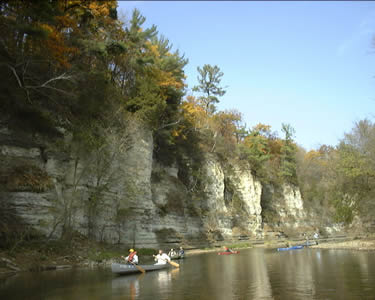
Tourism
& Economic Impact of the Upper Iowa River Watershed
The Upper Iowa River and its tributaries contribute greatly to the economic
health of the region, diversifying the opportunities for business and
tourism development in the region. The waters of Northeast Iowa are
a major attraction for anglers and other water recreationists. The Upper
Iowa Watershed is noted nationally for its fine fisheries. In 1998 the
Iowa DNR estimated over 314,000 angler trips per year are made to the
Upper Iowa River Watershed, stimulating over $29 million dollars of
economic activity each year. The Iowa DNR estimates canoeists enjoying
the Upper Iowa River generate another $5 million yearly. Local DNR Fisheries
Biologists consider these estimates, which are based on the area of
the watershed, to be extremely low. Thousands of visitors each year
tour the Iowa DNR Fish Hatchery in Decorah, Iowa, in the heart of the
watershed. Iowa DNR Fisheries and Fish Hatchery Management in Decorah
note, “the success of the operation of the hatchery and the success
of the trout rearing and stocking program is directly tied to the water
quality.”
 The
Winneshiek County Tourism Director states that “if the quality
of water declines, it will eventually have a negative impact on the
recreation aspect of tourism in Winneshiek County.” This statement
is based on research and surveys conducted by the Winneshiek County
Economic Development and Tourism Office. One survey found that the number
one tourism draw in Winneshiek County is the Upper Iowa River. That
survey also found the activities that bring visitors in direct contact
with the water of the Upper Iowa River and its tributaries (i.e. canoeing,
tubing, and fishing), were the primary outdoor recreational activities
of visitors to Winneshiek County.
The
Winneshiek County Tourism Director states that “if the quality
of water declines, it will eventually have a negative impact on the
recreation aspect of tourism in Winneshiek County.” This statement
is based on research and surveys conducted by the Winneshiek County
Economic Development and Tourism Office. One survey found that the number
one tourism draw in Winneshiek County is the Upper Iowa River. That
survey also found the activities that bring visitors in direct contact
with the water of the Upper Iowa River and its tributaries (i.e. canoeing,
tubing, and fishing), were the primary outdoor recreational activities
of visitors to Winneshiek County.
The Allamakee County
tourism office responds to over 1,160 calls per year regarding tourism
inquiries. The top three requests fall in the categories of fishing,
canoeing, and general outdoor activities. The economic impact of the
visitors generated by those calls is calculated at over $15 million
dollars annually.
The largest city
in the watershed, Decorah, is well known for its park system, which
includes over 500 acres of parks, most of which are focused around springs,
waterfalls, coldwater trout streams and/or the Upper Iowa River. The
Decorah Park Director notes that the city has committed spending to
highlight its water resources by strategically placing parks, trails,
campgrounds and amenities near water resources.
A 2003 report from
the Iowa Department of Economic Development estimated $7.65 million
dollars in payroll was generated in the Iowa counties included in the
UIRW. The same report revealed $45.92 million in total travel expenditures
in Howard, Winneshiek and Allamakee counties. These numbers reflect
a steady increase in tourism related expenditures and indirect water
quality related economic benefits for the communities and rural areas
in and around the UIRW. Dozens of small businesses related to the UIR
and coldwater trout streams also depend directly on the water quality
in the UIR and its watershed, including dozens of canoe, kayak and tubing
rental businesses, campgrounds adjacent to the water resources and rural
general stores located next to water features.